A powerful NASA satellite has confirmed what scientists have feared for decades: Mexico City sinking is no longer a slow-moving background concern — it is an accelerating emergency. New imagery from the NISAR satellite shows the city dropping nearly 10 inches every year. The same underground aquifer being drained to supply water to 22 million people is causing the ground beneath them to collapse. These two crises are not separate problems. They are one.
What makes this moment different is visibility. For the first time, scientists can track ground movement block by block, in near real time, from 464 miles above Earth. The data is striking — and alarming. Here is what it shows, why it is happening, and whether anything can still be done.
—
What NASA’s NISAR Satellite Just Revealed About Mexico City’s Sinking
How NISAR Measures Ground Collapse From 464 Miles Up
Launched in July 2025 as a joint mission between NASA and the Indian Space Research Organisation (ISRO), the NISAR satellite uses dual-frequency synthetic aperture radar to detect surface changes with millimeter-level precision. It scans the same locations every 12 days — through clouds, at night, in any weather.
Between October 2025 and January 2026, NISAR confirmed that parts of Mexico City sank more than 2 centimeters per month. That is not a geological estimate. That is direct measurement from space. No previous monitoring system could produce this kind of resolution at this scale or speed. For urban planners and disaster agencies, NISAR is a game-changer.
The Hotspot Zones: Where Mexico City Is Sinking Fastest
Not all of Mexico City is sinking equally. The worst-affected areas sit on the ancient lakebed of Lake Texcoco — soft, compressible clay that behaves almost like a sponge losing water.
- Iztapalapa: sinking up to 15 inches per year
- Chalco and Ecatepec (former Lake Texcoco basin): up to 20 inches per year
- Benito Juárez International Airport: structurally at risk from differential settling
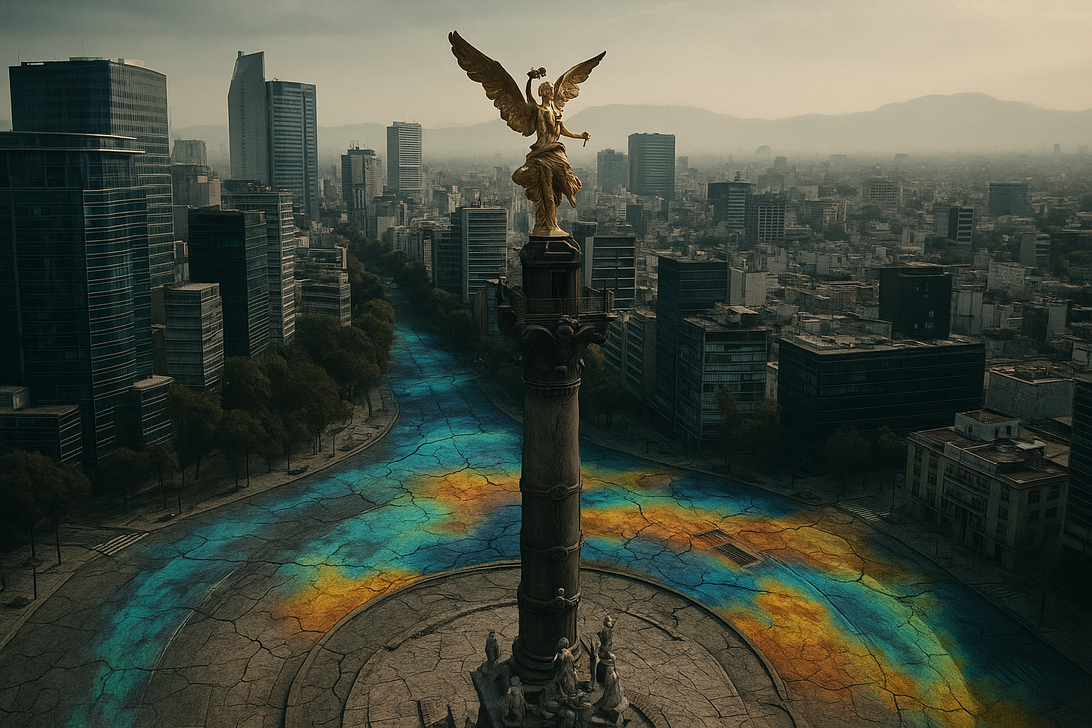
- Angel of Independence monument: now stands 14 steps above its original street level due to a century of accumulated sinking
These are not abstract data points. These are neighborhoods, schools, hospitals, and airports shifting beneath millions of people’s feet.
—
The Root Cause: How Draining an Ancient Aquifer Is Collapsing a Megacity
The Aquifer Math That Explains Everything
The numbers behind Mexico City’s aquifer depletion are stark. Nature replenishes the aquifer with roughly 25 billion cubic feet of water per year. The city extracts nearly 46 billion cubic feet annually — almost double the natural recharge rate.
When water leaves the aquifer faster than it can be replaced, the sediments that once held water lose their structural support. They compact. And under the immense weight of one of the world’s largest cities, that compaction accelerates. The ground does not just drop — it drops permanently.
Why Subsidence and Water Scarcity Are the Same Crisis
This is where the story gets more troubling. Land subsidence from groundwater extraction does not just lower the surface. It fractures pipes, breaks sewer lines, and contaminates the remaining groundwater — making the water shortage worse.
Researchers estimate Mexico City’s ancient clay lakebed will continue compacting for approximately 150 more years, even if all pumping stopped today. Up to 30 additional meters of total subsidence may still be locked in. The city is simultaneously running low on water and destroying the infrastructure it needs to deliver what little remains. That is a dual crisis with no easy exit.
—
Can Mexico City Be Saved? Lessons From Tokyo, Shanghai, and the Road Ahead
How Tokyo and Shanghai Stopped Sinking — And What Mexico City Can Learn
Tokyo and Shanghai both faced severe land subsidence from groundwater extraction in the 20th century. Tokyo sank nearly 4 meters between the 1900s and 1970s. Shanghai dropped significantly across industrial zones. Both cities reversed course.
Their solution involved three steps: strict limits on groundwater extraction, sourcing water from surface rivers and reservoirs instead, and artificial aquifer recharge programs. Within decades, sinking rates slowed dramatically in both cities. The lesson is clear — this crisis is manageable. But it requires political will, investment, and early action based on reliable data.
What Mitigation Looks Like: Satellites, Policy, and Aquifer Recharge
Mexico City’s government has largely treated subsidence as a monument-preservation problem rather than a systemic emergency. That may finally be changing. Recent water crisis flare-ups and NISAR’s high-resolution monitoring data are pushing new research and policy conversations forward.
NISAR’s building-by-building detail gives authorities something they never had before: a precise map of where intervention is most urgent. Paired with aquifer recharge programs, alternative water sourcing from surface systems, and serious infrastructure investment, there is a viable path forward. But experts are clear — billions in coordinated spending and binding groundwater policy reform are still required before the data alone can save anyone.
—
Frequently Asked Questions
Why is Mexico City sinking so fast?
Decades of over-extracting groundwater from a soft, ancient clay lakebed have caused sediments to compact irreversibly under the city’s weight. The faster water is removed, the faster the ground collapses — and extraction has run at nearly double the natural recharge rate for years.
How much has Mexico City sunk in total?
Mexico City has sunk more than 39 feet (12 meters) over the past century. Current rates reach nearly 10 inches per year on average, with the worst-affected zones dropping up to 20 inches annually.
What is the NISAR satellite and why does it matter for Mexico City?
NISAR is a joint NASA-ISRO radar satellite launched in July 2025 that tracks ground movement with millimeter precision every 12 days from space. It enables real-time subsidence monitoring at a resolution and speed no previous system could match.
Will Mexico City run out of water — what is Day Zero?
Day Zero describes the point when a city’s taps run dry. Mexico City faces this risk because over-extracting its aquifer simultaneously depletes water supply and damages the pipe infrastructure needed to deliver it.
Can Mexico City’s sinking be stopped or reversed?
The clay compaction is irreversible, but the rate of sinking can be slowed through groundwater limits, aquifer recharge, and alternative water sourcing — exactly the approach that stabilized Tokyo and Shanghai.
—
Conclusion
Mexico City’s sinking is a century-in-the-making crisis now fully visible from space. NISAR has handed scientists and policymakers an unprecedented tool — and with it, a closing window for action. For 22 million residents, the dual threat of subsidence and water scarcity demands immediate, coordinated response. The story of Mexico City is also a warning for every megacity built on geologically sensitive ground. Understanding the problem at this scale is not the finish line — it is finally the starting gun.
Leave a Reply