Introduction
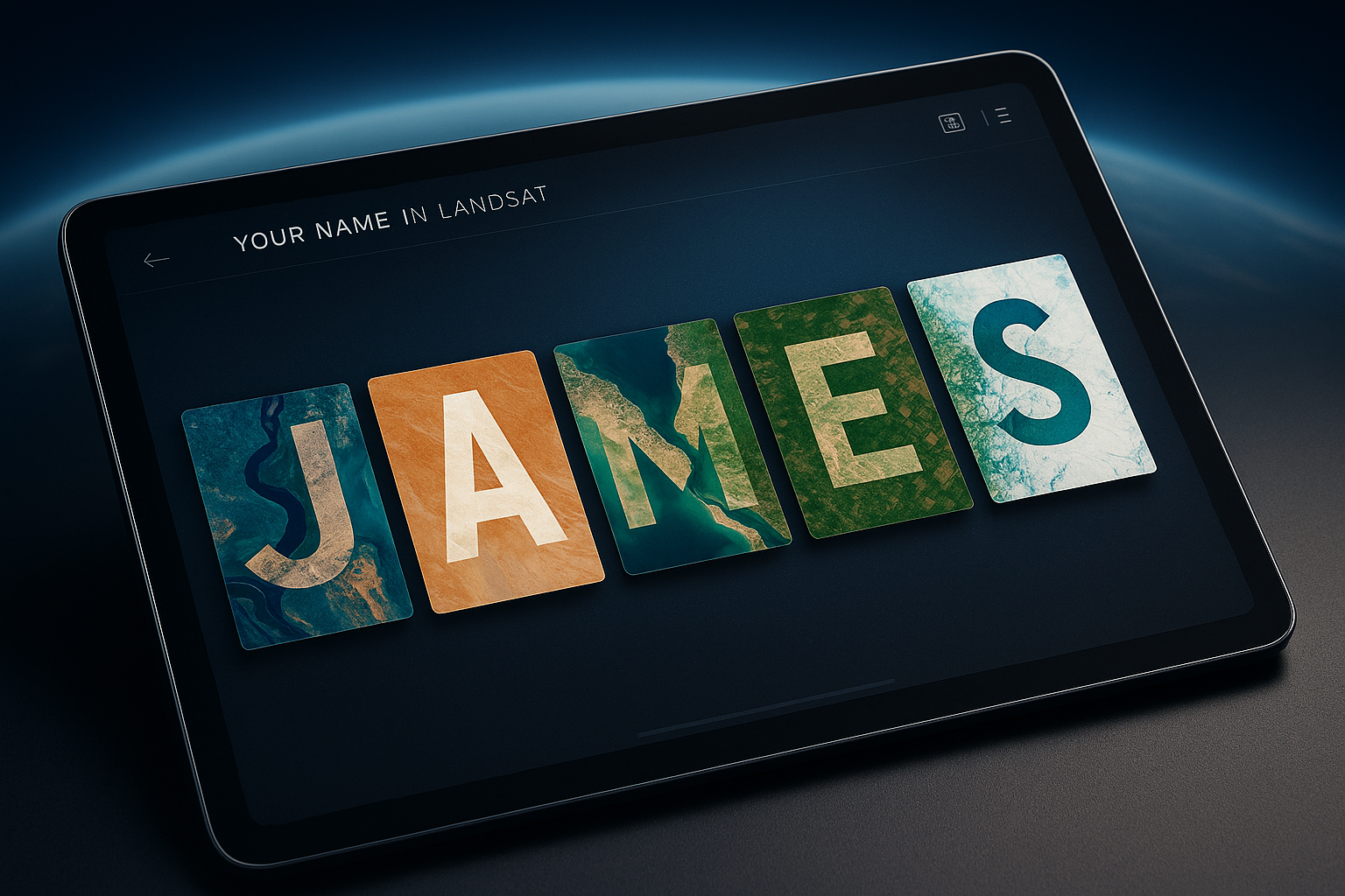
NASA just let Earth spell your name — and the internet loves it. The agency’s Your Name in Landsat tool exploded across social media after NASA’s Kennedy Space Center promoted it on Earth Day 2026, racking up 184K reposts and 60K likes almost instantly. Millions of users have since generated their own personalized satellite name posters, and searches for “NASA spell your name” surged past 100,000 practically overnight.
Table of Contents
- Introduction
- How to Use the NASA ‘Your Name in Landsat’ Tool (Step-by-Step)
- The Real Science Powering Every Letter: What Is Landsat?
- Why NASA Built This Tool & What Landsat Data Really Does
So what exactly is this tool, and why does it hit differently than your average viral moment? Because every letter in your name is built from real satellite imagery — actual rivers, coastlines, and desert ridges photographed from space over 50+ years. This guide walks you through how to use it, what science powers it, and why it matters beyond the share button.
—
How to Use the NASA ‘Your Name in Landsat’ Tool (Step-by-Step)
The tool is surprisingly simple to use, but there are a few tricks that make the experience much better. Here’s everything you need to know.
Step-by-Step: Generating Your Landsat Name Image
Getting started takes under two minutes. Follow these steps:
- Go to science.nasa.gov/specials/your-name-in-landsat
- Type your name in the input box — the tool supports all A–Z letters
- Press Enter to generate your satellite image name poster
- Press Enter again to cycle through alternate landscape photos for any letter you want to swap out
- Download individual letters by clicking on each tile separately
- Export the full name poster as a single image for clean social sharing
- Use the built-in QR code to share directly from a phone
- Hit the copy-link button to paste your unique poster URL anywhere
Each letter tile is pulled from a different real-world location. Don’t love how your “S” looks? Hit Enter again and Earth will offer you another river bend to try. The tool is rated for ages 10 and up, works directly in your browser, and requires zero downloads or account creation.
One underrated feature: hover over any letter tile to reveal the real-world geographic coordinates of that exact landscape. That mountain ridge forming your “A”? You can find out exactly where on Earth it lives.
Sharing, Downloading & QR Code Export Tips
Once you’ve built your name, sharing it is just as easy:
A few practical tips: if you’re posting to Instagram, the full poster export works best as a square crop. For Twitter or X, individual letter tiles can make for a fun thread. Teachers using this in classrooms can generate posters for each student’s name and use the coordinate feature to spark a geography lesson.
—
The Real Science Powering Every Letter: What Is Landsat?
The fun of the name poster is real — but so is the science underneath it. Understanding where these images come from makes the tool genuinely impressive.
50+ Years of Earth Observation: Landsat’s Record-Breaking Legacy
The Landsat program is a joint effort between NASA and the U.S. Geological Survey (USGS). It launched its first satellite on July 23, 1972 — making it the longest continuous space-based record of Earth’s land surface ever created.
Images powering the name tool are sourced from NASA Earth Observatory, NASA Worldview, USGS EarthExplorer, and ESA Sentinel Hub. That’s decades of data, captured across multiple spectral wavelengths, stitched together into a searchable archive that scientists and now — thanks to this tool — everyday people can actually see and connect with.
How Rivers, Coastlines & Deserts Become Letters
Here’s the clever part: no one at NASA manually drew letters onto satellite photos. The shapes you see are entirely natural.
The effect relies on pareidolia — the human brain’s hardwired tendency to find familiar shapes in random patterns. Winding rivers naturally trace S-curves. Lake shorelines mirror the arch of an A. Straight irrigation boundaries on farmland can look like H or I. NASA’s team curated real Landsat images where these formations are especially clear and letter-like, then matched them to the alphabet. What you’re seeing is Earth, completely unedited, just viewed from 438 miles up.
—
Why NASA Built This Tool & What Landsat Data Really Does
This tool didn’t appear out of nowhere. It has a clear mission — and a track record of real-world impact behind it.
From Earth Day Campaign to Long-Term Science Outreach
The Your Name in Landsat tool originally debuted in August 2024 as part of NASA’s virtual Camp Landsat summer program for students. NASA re-promoted it for Earth Day 2026 under the theme “Our Power, Our Planet” — a deliberate strategy to make Earth science feel personal and accessible to non-scientists.
The goal is straightforward: if people see their own name written in a Saharan sand dune or an Alaskan river delta, they’re more likely to care about the data that captured it.
Landsat’s Real-World Impact: Climate, Forests & Land Use
Landsat isn’t just pretty pictures. Researchers rely on its 50-year archive to track:
In 2023 alone, Landsat data generated an estimated $25.6 billion in economic value to the U.S. through environmental monitoring, land-use planning, and disaster response applications. Your name poster is built on that same archive.
—
Frequently Asked Questions
How do I spell my name using NASA’s Landsat tool?
Visit science.nasa.gov/specials/your-name-in-landsat, type your name into the input box, and press Enter to see it rendered in real satellite imagery. Press Enter again to cycle through alternate landscape images for any letter you’d like to change.
Is NASA’s ‘Your Name in Landsat’ tool free to use?
Yes, the tool is completely free — no account, no subscription, and no download required. All NASA Landsat data is publicly available by law, which means this interactive will stay free to access.
What satellite images does the NASA name tool use?
Images are drawn from over 50 years of Landsat records, sourced from NASA Earth Observatory, NASA Worldview, USGS EarthExplorer, and ESA Sentinel Hub. Each letter represents a real, unedited landscape photographed from space.
Can I download or share my NASA Landsat name image?
Yes — you can download individual letter tiles or export your full name as a single poster image. The tool also includes a built-in QR code and a copy-link button for instant social sharing.
Why was the NASA Landsat name tool launched on Earth Day 2026?
NASA timed the tool’s viral promotion to Earth Day (April 22, 2026) under the theme “Our Power, Our Planet” to make satellite Earth science personally engaging for a global audience. The Earth Day moment gave the campaign massive organic reach, with 184K reposts recorded within hours of the original post.
—
Conclusion
The NASA spell your name tool is a genuinely clever piece of science outreach — one that turns 50 years of uninterrupted Earth observation into something personal and shareable. Every river curve and ridgeline forming a letter in your name is real data that researchers use daily to track climate change, deforestation, and land use. Try it at science.nasa.gov, generate your poster, and share it. What does Earth spell for you?
Leave a Reply