Over 235 million Americans are bracing for one of the most dangerous winter weather events in years as a polar vortex collapse sends Arctic air plunging southward. If you’ve noticed meteorologists using increasingly urgent language lately, there’s good reason. What’s happening 30 miles above Earth’s surface is about to make your February dramatically colder than normal.
This isn’t your typical winter cold snap. The stratospheric warming event currently disrupting the polar vortex has created conditions that will bring prolonged Arctic temperatures to regions from Texas to New England. Some areas could see temperatures 20-30 degrees below normal for extended periods. Understanding what’s happening—and how to prepare—could make the difference between inconvenience and genuine danger for you and your family.
Understanding the 2026 Polar Vortex Collapse: The Science Behind the Extreme Cold

What Is a Polar Vortex and Why Does It Collapse?
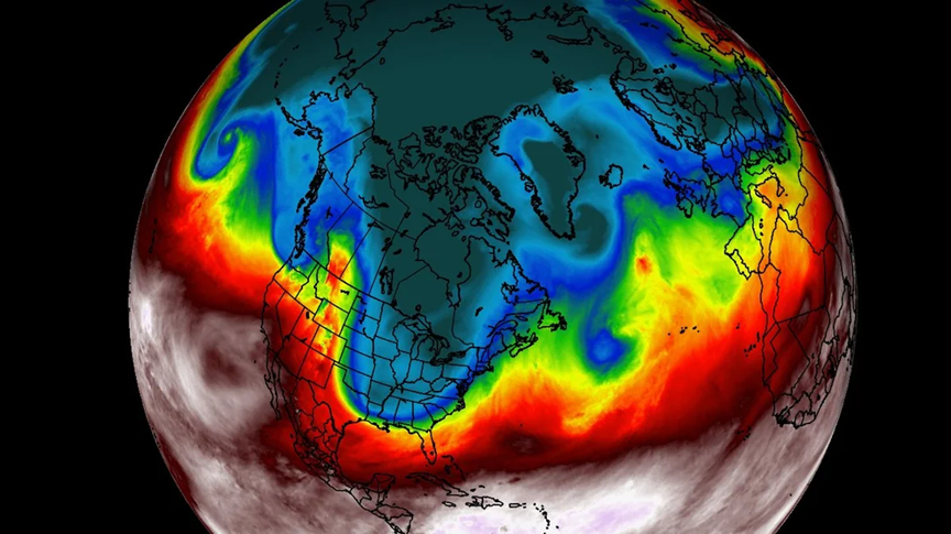
Think of the polar vortex as a massive whirlpool of cold air spinning around the Arctic, roughly 30 miles above Earth’s surface in the stratosphere. When this circulation remains strong and stable, it keeps Arctic air locked up north where it belongs. But when it weakens or becomes distorted, that frigid air can break free and spill southward across North America.
The term “collapse” describes what happens when the vortex’s normal west-to-east circulation weakens dramatically. Instead of spinning tightly around the pole like a well-organized fence, it stretches, wobbles, or even splits apart. This allows massive chunks of Arctic air to escape southward, bringing the kind of bitter cold typically reserved for Alaska to places like Atlanta or Dallas.
Not every winter produces a polar vortex disruption. When they do occur, the impacts can last for weeks, affecting everything from your heating bill to flight schedules to school closures.
The Stratospheric Warming Event Triggering This Winter’s Chaos
The current situation traces back to a sudden stratospheric warming (SSW) event that began in mid-January 2026. During an SSW, temperatures in the stratosphere can spike by 50 degrees or more within just a few days. This rapid warming disrupts the polar vortex’s circulation, causing it to weaken and deform.
Scientists point to exceptionally low sea ice coverage in the Barents and Kara Seas north of Russia as a contributing factor. When these Arctic waters remain ice-free later into winter, they pump extra heat and moisture into the atmosphere, creating waves of energy that propagate upward and literally punch the stratospheric circulation.
The January 2026 event represents a stretching and displacement of the vortex rather than a complete split. While that might sound less severe, stretched events can actually produce longer-lasting cold patterns at the surface. The jet stream disruption caused by this weakening has already begun steering Arctic air masses southward, and the worst is yet to come.
Regional Impact Timeline: When and Where the Arctic Blast Will Strike
Current Conditions and Immediate Threats (January 24-31)
A major winter storm is currently carving a path from Texas through the Southeast and into the Northeast. If you’re in the southern tier, ice is your biggest concern. Freezing rain is coating surfaces from Dallas to Atlanta, with accumulations reaching a quarter to half-inch in some areas. That’s enough to snap tree limbs, down power lines, and make roads completely impassable.
The same storm is bringing heavy snow to the Midwest and Northeast, with some metro areas expecting 8-14 inches. Behind the storm, truly Arctic air is pouring southward. Minneapolis could see wind chills approaching -40°F. Chicago is looking at actual air temperatures below zero for several consecutive days. Even Nashville and Memphis face dangerous conditions with lows in the single digits.
Temperature departures from normal are staggering. Much of the eastern United States will experience readings 15-30 degrees below average. Cities accustomed to January highs in the 40s and 50s may struggle to reach 20°F. This isn’t a one-day event—the cold air mass is massive and slow-moving.
Extended Outlook: Cold Pattern Through February
The immediate blast is just the opening act. The disrupted winter weather pattern is expected to persist through at least the first week of February, possibly longer. Meteorological models show waves of cold air continuing to dive southward in pulses.
What makes this particularly challenging is the snow cover amplification effect. Fresh snow on the ground reflects sunlight and allows temperatures to drop even further overnight. Areas that receive significant snowfall from the current storm could see enhanced cold in subsequent waves.
The highest-risk regions for extended impacts include the Great Lakes and Upper Midwest, where subzero temperatures could persist for a week or more. The Southeast faces repeated threats of dangerous ice as moisture streams encounter the cold air. The Northeast can expect several more snow events as coastal storms interact with the frigid continental air mass. Even the normally milder Mid-Atlantic states should prepare for a prolonged period of below-normal temperatures that could stress heating systems and create frozen pipe risks.
Essential Preparation and Safety Strategies for Polar Vortex Conditions
Protecting Your Home from Extreme Cold and Power Outages
Your home’s vulnerability to extreme cold extends beyond just running up your heating bill. Start with your pipes—any plumbing in unheated spaces needs immediate attention. Let faucets drip slightly during the coldest nights, especially those on exterior walls. Open cabinet doors under sinks to allow warm air circulation.
Remember the 2021 Texas grid failures? Now is the time to prepare for potential power outages. Assemble an emergency kit with flashlights, batteries, blankets, and non-perishable food. If you use a generator, never operate it indoors or in an attached garage. Carbon monoxide poisoning kills quickly in enclosed spaces.
Check your heating system now, not when it fails at 2 AM during subzero temperatures. Replace filters, ensure vents aren’t blocked, and consider having a professional inspection if your system is older. Stock up on any necessary fuel. Reverse ceiling fans to push warm air downward. Seal drafts around windows and doors with weatherstripping or plastic film.
If you must leave your home for an extended period, don’t turn the heat off completely. Set the thermostat no lower than 55°F to prevent pipe freezing.
Personal Safety: Recognizing and Preventing Cold-Weather Hazards
Frostbite can occur in as little as 10 minutes when wind chills drop below -20°F. Early signs include numbness and white or grayish-yellow skin. Your extremities—fingers, toes, nose, and ears—are most vulnerable. Layer clothing appropriately, with moisture-wicking base layers, insulating middle layers, and windproof outer layers.
Hypothermia develops when your body loses heat faster than it can produce it. Watch for shivering, exhaustion, confusion, and slurred speech. The elderly and very young are particularly susceptible. If you must go outside, limit exposure time and take warm-up breaks.
Driving becomes treacherous during ice events. Black ice is nearly invisible. If you must travel, reduce speed significantly, increase following distance, and avoid sudden braking or acceleration. Keep an emergency kit in your vehicle including blankets, water, snacks, and a charged phone.
Check on elderly neighbors and family members. Ensure they have adequate heating, medication, and food supplies. Visit the National Weather Service for the latest warnings and advisories specific to your location.
Frequently Asked Questions
How long will the polar vortex collapse last in 2026?
The extended cold air outbreak pattern is forecast to continue through the end of January and into early February 2026. Rather than one continuous deep freeze, expect alternating waves of bitter cold and brief milder breaks, with overall below-normal temperatures persisting for 2-3 weeks.
Is the polar vortex collapse related to climate change?
Research increasingly suggests that Arctic warming and reduced sea ice coverage may make polar vortex disruptions more frequent, though the science remains actively debated. What’s clear is that a warmer Arctic affects atmospheric patterns, potentially creating the conditions that allow stratospheric warming events to occur.
What’s the difference between a polar vortex disruption and collapse?
A disruption means the vortex becomes stretched, displaced, or weakened but maintains some structure, while a collapse involves a complete breakdown or splitting into multiple pieces. Both can produce severe cold outbreaks, though splits often generate the most extreme and widespread impacts.
Which US states will be most affected by the 2026 polar vortex?
Texas through Georgia face particularly dangerous ice accumulation threats, while the Midwest and Great Lakes region will experience subzero temperatures and dangerous wind chills. The Northeast can expect heavy snow and prolonged cold, with impacts extending across the entire eastern two-thirds of the United States.
Can meteorologists predict polar vortex disruptions in advance?
Scientists can detect stratospheric warming events 1-3 weeks before they occur, but translating those high-altitude changes into specific surface weather impacts remains challenging beyond 7-10 days. This lead time allows for general preparation but not precise local forecasts until the pattern develops.
Conclusion
The 2026 polar vortex collapse serves as a stark reminder that seemingly distant atmospheric events can profoundly impact your daily life. The science might be complex, but the response doesn’t have to be. Monitor forecasts from official sources, take the preparation steps outlined above, and prioritize safety over convenience. This Arctic outbreak will eventually pass, but the decisions you make in the coming days will determine whether you experience a memorable winter story or a dangerous crisis. Check on vulnerable neighbors, stock emergency supplies, and winterize your home now—before the worst conditions arrive.
Leave a Reply